I am happy to say the Second Republic has lived true to that allocative commitment, which is how we have been able to support innovation hubs and develop new and appropriate, home-grown technologies, wholly suited to the needs of our industries, and our communities in their quest to industrialise our rural areas.
Education 5.0 has a specific section devoted to Geospatial, Aeronautical and Space Science.
That section sired the Zimbabwe National Geospatial and Space Agency (ZINGSA), which has been at the heart of the development of ZIMSAT-1. We spelt out ZINGSA’s mission thus: “The Agency shall design and conduct research and development initiatives that promote advances in Geospatial Science and Earth Observation, Space Science, Space Engineering, Aeronautical Engineering, Astronautical Engineering, Satellite Communications Systems, Global Navigation Satellite Systems (GNSS), Land Positioning Systems, Unmanned Aerial Vehicles (UAVs) and launch Satellites.”
I opened ZINGSA at the University of Zimbabwe in 2018, amidst palpable scepticism. Many thought this was rank madness by some starry-eyed dreamers, was something well beyond our reach given the myriad challenges we grappled with at the time. Our infrastructure was broken; our economy was in a state of collapse; we endured long hours of power outages. Yet there we were, dreaming about participating in space economy!
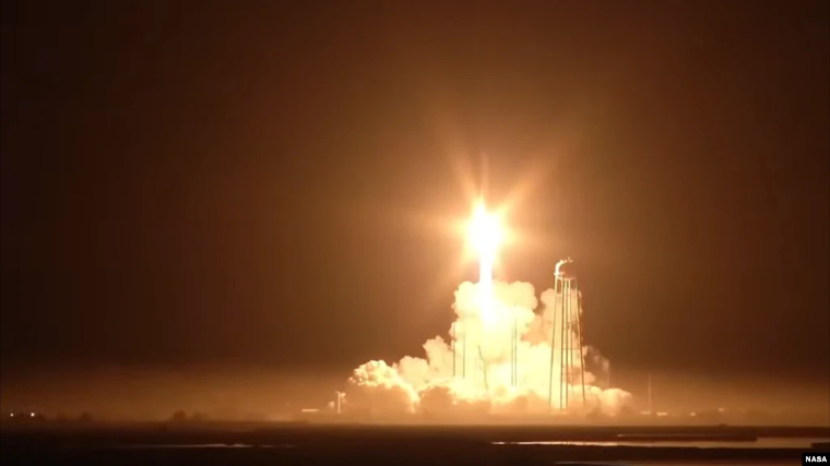
Today we celebrate that ZINGSA has delivered on its mandate, making Zimbabwe a Space Nation. Of course, that we named our maiden satellite ZIMSAT-1 means we foresee the launch of more satellites as our Nation fully exploits and harnesses space technology for rapid industrialisation and modernisation. Indeed, ZIMSAT-2 is on its way, and should be a lot easier given the expertise, experience and confidence we have now garnered through this multinational partnership.
ZIMSAT-1 allows us to “see” our country from outer space. It is our outer-inner eye which enables us to grasp and understand our country from several angles, including its physical environment, its geological attributes and endowments, our weather patterns and our human settlements. With that vast, enhanced capability, we should be able to inventory our subsoil assets, our flora and fauna, to anticipate disasters, weather patterns and to map our total human settlement and land use plans. We are also able to make key interventions in national health, including foreseeing pandemics in time for timeous responses. The possibilities are immense and limitless, making this a worthwhile venture and investment.
Continued next page
(206 VIEWS)